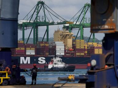
A single ship moving through a narrow strip of water shouldn't be world news. But when that water is the Strait of Hormuz, the world holds its breath. We've seen the recent time-lapse footage showing the first wave of vessels cutting through these waters after the latest bout of regional tension. It's mesmerizing to watch those glowing dots on a maritime tracker crawl across the screen. It looks simple. It isn't.
If you're looking at those time-lapse videos and thinking it's just about logistics, you're missing the point. The Strait of Hormuz is the world's most sensitive windpipe. When it constricts, the global economy starts to gasp for air. Seeing those first ships move through isn't just a win for shipping companies. It's a temporary sigh of relief for energy markets that were bracing for a total cardiac arrest.
Why this narrow stretch of water dictates your gas prices
The Strait of Hormuz is barely 21 miles wide at its narrowest point. That's a shorter distance than most people's morning commute. Yet, about 20% of the world's total petroleum liquids—nearly 21 million barrels a day—pass through this tiny gap. You can't just "go around" it. The only alternatives are a few pipelines through Saudi Arabia and the UAE, and they don't have the capacity to handle what the tankers do.
When we see the first ships crossing in these time-lapse sequences, we're seeing the physical manifestation of "de-escalation." Insurance companies, which are the real masters of the sea, don't let those tankers move unless they're reasonably sure they won't be seized or hit by a drone. The movement you see on screen is actually a data point proving that back-channel diplomacy worked. For now.
The mechanics of the crossing are a high stakes dance
Watching the time-lapse, you notice the ships follow very specific lanes. These aren't suggestions. There's a Traffic Separation Scheme (TSS) in place to keep inbound and outbound tankers from colliding. The lanes are only two miles wide, separated by a two-mile wide buffer zone.
Imagine driving a vehicle the size of an office building through a lane that feels like a tightrope, all while knowing that multiple navies are watching your every move through radar and satellite. The Iranian Navy and the Islamic Revolutionary Guard Corps Navy (IRGCN) operate in these waters constantly. On the other side, the U.S. Fifth Fleet and various international coalitions keep a permanent watch. It's the most crowded, tense parking lot on Earth.
The time-lapse footage often speeds up the movement to make it look like a fluid stream. In reality, these ships are moving at a crawl. They're vulnerable. Every time a ship enters the Strait, the captain is weighing the "War Risk" surcharges they've paid to be there.
What the cameras don't show you
- Electronic Interference: Ships in the Strait often report GPS interference or "spoofing." Sometimes their navigation systems tell them they're in the middle of an airport in Iran when they're actually in the shipping lane.
- Bridge Tension: The silence on the bridge during these transits is heavy. Crews are trained to look for small, fast-attack craft that can swarm a larger tanker in minutes.
- Communication Shadowing: Ships are constantly hailed by local authorities. Knowing which voice on the radio to trust is part of the job.
The economic reality of the first transit
Why does the "first ship" matter so much? Because it sets the price. When the Strait is perceived as closed or high-risk, Brent Crude prices spike. This isn't theoretical. We've seen $5 or $10 premiums added to a barrel of oil just based on a rumor of a naval exercise.
When the time-lapse shows that first successful crossing, it signals to the markets that the "Risk Premium" can be dialed back. It's a signal to refineries in Asia—the primary destination for this oil—that they don't need to panic-buy from other sources. China, India, Japan, and South Korea get the vast majority of their energy through this chokepoint. If those ships stop, their economies stall.
Security isn't just about big grey ships
The protection of these vessels has evolved. It's not just about destroyers patrolling the horizon anymore. It's about a massive, invisible web of intelligence. We're talking about the International Maritime Security Construct (IMSC) and other coalitions that provide "sentinel" services. They use a mix of aerial surveillance, satellite imagery, and shared communication to give these tankers a clear path.
But even with all that tech, the physical geography is the boss. The shipping lanes go through Omani and Iranian territorial waters. Under the United Nations Convention on the Law of the Sea (UNCLOS), ships have the right of "transit passage." This means as long as they keep moving and don't act as a threat, they can go through. But "threat" is a word that's open to interpretation when tensions are high.
How to track this yourself without the hype
If you want to see what's actually happening without waiting for a news outlet to post a curated time-lapse, you should look at AIS (Automatic Identification System) data. Sites like MarineTraffic or VesselFinder give you a real-time look at the bottleneck.
Look for the "anchorage" areas near Fujairah in the UAE. That's the waiting room. When you see the cluster of ships there starting to thin out and move north toward the Strait, you know the situation is stabilizing. If you see ships turning their transponders off (going "dark"), that's when you should actually worry. That's a sign that captains are trying to hide their position to avoid seizure or that they're engaged in "shadow" trade.
Watching the first ships cross isn't just a cool visual. It's a lesson in geography's absolute power over our modern, digital lives. We can trade stocks in milliseconds, but we still need 300,000-ton steel boxes to move through a 21-mile gap to keep the lights on.
Keep an eye on the volume of "crude oil tankers" vs "LNG carriers" in the next few days. The LNG (Liquefied Natural Gas) movement is particularly critical for European and Asian heating. If those ships are moving smoothly in the time-lapse, the energy crisis is being managed. If they're loitering outside the Strait, expect your utility bills to reflect that delay very soon. The footage is a scorecard. Learn how to read it.